Moray West project completion success
Press release
The project, originally known as the Western Development Area of the Moray Firth part of the Round 3 Crown Estate concessions, contracted EOLOS as turn-key provider of wind and ocean measurements in summer 2018 to provide highly accurate, bankable wind data to supplement existing data. Twenty-four months of continuous campaign measurement has been completed, with market leading reliability and performance. Back in 2018 the contract was the first project for EOLOS in UK waters, to which similar campaigns are now underway in both the Celtic Sea and the Irish Sea.
Ocean Winds Energy Assessment and Metocean representative for the project, Guillermo Tornero de Diego providing the following written statement to EOLOS on 23rd December 2020:
“After two and half years of working with EOLOS on the Moray West metocean measurement campaign we are delighted to reach the important milestone of decommissioning the measurement buoy. This marks the conclusion to a successful measurement campaign that allows the project to move forward to a bankable yield assessment.
The two-year campaign has been completed without incident and excellent performance and data availability. The Moray West team is grateful for the proactive approach by the EOLOS team, particularly given the challenges presented by Covid.”
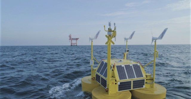
The industry of floating LiDAR, which has established itself as a data-as-a-service business model, typically works to stringent performance indicators, striving to give consistently reliably and accurate data even in the harshest environments, throughout the campaign term. Ocean Winds confirms that EOLOS achieved a remarkable average over the consolidated two years of 95% post-processed availability. The campaign’s term and performance provide another tick-in the box for exceeding the Carbon Trust’s “Stage 3” key performance indicators.
Sales Director, Julian Harland resonates “The operational success of this prestigious campaign is clearly a credit to our entire team, recognising the EOLOS buoy’s inherently robust design and also the high wind data availability across all measurement heights of the industry recognised ZX 300M LiDAR from our UK-based supplier, ZX Lidars.”
Its pleasing for the entire industry that site-specific measurements in the hostile environment of the North Sea are recognised as bankable when carried out by floating LiDAR devices, delivering results upon which established developers such as Ocean Winds will make very significant capital investment decisions.”
About Moray West Offshore Windfarm
The Moray West offshore wind farm, located in the Moray Firth, Scotland, is a key part of the energy transition and the drive to Net Zero carbon emissions. Now fully consented the project is developing engineering detail at the same time as securing a route to market in advance of construction starting. The current planning is based on the project being operational in 2024/25.
The project stands to make a vital contribution to Scotland’s renewable energy and climate change targets. Regional and national supply chains have benefitted from investment during the development phase and will benefit from construction and the 25-year operational period. From our offices in Scotland the project team is working closely with communities, supply chain and other stakeholders to ensure the success of the project with minimal disruption to local people.
Ocean Winds is a 50:50 offshore wind joint-venture, owned and created by EDPR and Engie in 2019.
Both companies believe that offshore wind energy is becoming an essential part of the global energy transition, leading to the sector’s rapid growth and increased competitiveness. That is why they have included all their existing and pipeline offshore portfolio in the new company.
A 5% stake is held by Lithuanian based Ignitis.
About EOLOS
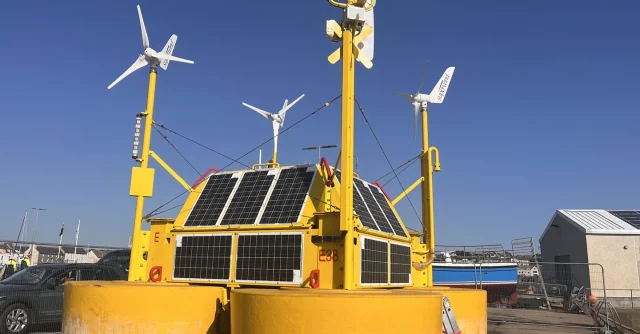
EOLOS Floating Lidar Solutions offers turn-key measuring solutions to the offshore wind industry. Its product, the EOLOS FLS200, is a highly robust validated floating buoy that uses LiDAR (light detection and ranging) technology to gather high-quality wind and ocean data from any offshore location. It enables wind farm planners to perform wind measurements at heights of more than 200 metres above sea level, and to calculate wave and current movements up to depths of 300 metres. As a floating buoy, the EOLOS FLS200 provides for fast installation and rapid re-location to other areas within a wind farm site or to completely new sites when required.
To find out more visit:
www.oceanwinds.com
https://ignitis.lt/en/about-us
https://www.moraywest.com/
https://www.eolossolutions.com
Annexes
Notification to Mariners – decommissioning https://www.moraywest.com/download_file/896/204
More news
Monitoring launched at Stromar Floating Offshore Wind Farm site
EOLOS ties-up with Windpal for offshore wind resource and metocean data measurements in Japan